After visiting the gorges, we arrive in Alice Springs (G’day Mate Caravan Park) that
afternoon, setting up camp and going shopping for some essentials. The sun was still very hot so it was back to
camp and straight to the swimming pool in the Caravan Park.
That night we spoke about way we were going to head
home. Initially we were heading back via
Tennant Creek, Barkley Highway, Mt Isa and then down, but it appears there is a
heat wave up there, hitting low 40’s, so it was decided to head south, down to
Port Augusta and across.
The following day was he final shop before we all headed
South and across to the Eastern States.
ON our way back from shopping, we called into the Royal Flying Doctor
Service at Alice. It was a pretty new
building, encompassing the old building.
For a small cost, you could watch a film on the RFDS and its history, as
well as a tour of their local museum.
The girls enjoying role playing in the cockpit of a replica RFDS plane, which
is in their building. They both donned
the ear muffs and grabbed the control stick, playing games of rescuing people
who had been hurt.
We then visited the Alice Springs Gaol, where there was
exhibition depicting The Australian Women’s Hall Of Fame, ladies who had been
on the frontier of cattle ranching, business, aviation and many other frontiers
for women. It was very good, well worth
the small cost.
The next day, it was time to pack up and head south, so it
was an early start, with Daz, Bec, Paul and Nat saying our goodbyes to Alice
Springs and thanking her for being a good host.
We crossed the NT/SA Border.
We crossed the NT/SA Border.
It was a long day, with several fuel stops along the
way. We hit Coober Pedy, with some
unfinished business to be had by Nat, with her shopping and also a
fuel stop.
We spoke over the UHF about where we were going to stop, as
it was about 3.30pm, when we left Coober Pedy.
Out camp the Camps 7 book as well as the ‘plasma’ wiki camps app on the
tablet. After much debate and watching
the free camps as we travelled past them, we stopped at Bon Bon Rest area,
which was about 70km North of Glendambo. There
isn’t much there except for a toilet and flat ground, which was quite open.
When we stopped, the sun was setting, with the wind blowing
with some force. We all thought the wind
would lessen, as night fall approached, but it didn’t. A quick dinner, noodle cups, washed down with
a few beers, saw Dazza, paul and myself up on my camper, taking the sun roof
off, as the wind had increased in speed and the sun roof was like a sail,
dragging the tent. A few more pegs in
the ground, but still the wind increased in strength.
Dazza, then told me he was unhitching and moving his patrol
in front of his tent, trying to deflect the wind. I did the same and then started tying ropes
from the tent to the bull bar and roof rack, in an attempt to stop the wind
blowing it away. Both Dazza and I looked
at one and other, saying,’that’s the bext we can do.” Mean while, Paul had opened all his windows
in his camper, to let the wind blow right through, except to say the dust and
dirt that was being blow up from the rest area.
I climbed into bed with Deb and the girls. They were all fairly scared with the wind
blowing hard. Deb thought the ribs
(stays which hold up the tent) were going to pull out, sending the tent flying
of the tent. I assured her it was not
going to happen.
These are the morning after shots.
These are the morning after shots.
It was a long night, with the wind settling before
morning. We all woke, looking somewhat
tired. A quick pack up and we headed for Glendambo, where it was bacon and eggs
rolls for us, followed by some ordinary coffee.
We continued south on the Stuart Highway, towards Port
Augusta, with a short stop off in Woomera. I had always wanted to visit Woomera and see some of the space craft/rockets that were used out here in the 50's, 60's & 70's. I wish we could have seen some of the stuff, that is still prohibited.
We continued on to Port Augusta, which looked like a nice town, we had left the dryness behind and it opened up onto the Spencer Gulf. Nat found a fish and chips shop, which we headed for. Fish and chips for all, except Deb had a chicko roll. Down to the edge of the Spencer Gulf, we ate lunch and talk about where to next, as it was either going to be North East to Broken Hill or East to Renmark.
We continued on to Port Augusta, which looked like a nice town, we had left the dryness behind and it opened up onto the Spencer Gulf. Nat found a fish and chips shop, which we headed for. Fish and chips for all, except Deb had a chicko roll. Down to the edge of the Spencer Gulf, we ate lunch and talk about where to next, as it was either going to be North East to Broken Hill or East to Renmark.
It was decided to head for Broken Hill, so off towards
Petersborough, we headed. Petersborough
is an old Steam Train area, between Port Augusta and Broken Hill. As we travelled across the hills, both Deb
and commented how beautiful the area was.
The area had recently had some good rain, with the crops and farm
animals doing very well.
We found another free camp on the northern edge of
Petersborough, arriving about 4.30pm.
This free camp was totoally the opposite to Bon Bon, it was sheltered,
with trees and grass. There were a few
other campers, but it didn’t feel crowded.
Before we started this trip, our research had indicated, the
weather would be very cold over night and warm during the day, well this was
the opposite to what we had encounted until now. The cold weather clothes, including beanies,
jackets, scarves and gloves had been packed away, but as the sun slowly went
down, it become clear, it was going to be a cold night. Each family scambled to get all of the cold
clothes out of bags, so we stayed warm.
Nat was the first to come out of her tent, dressed in long
tights, jacket, scarf, beanie and gloves.
It was a sight to behold, but it was not long before most of the others,
were wearing similar clothes.
It was early to bed that night due to the coldness. I had left a thermometer on the spare tyre
and the next morning, the dew was frozen, with the temperature reading
-1.3c. It had been the coldest night
thus far.
Again, another quick pack up, toilet stop back in
Petersborough and we continued our trip to Broken Hill.
We crossed the SA/NSW.
We did the usual tourist thing in Broken Hill, with a few photographs from the top of one of the mines, with the kids sitting a large bench seat.We crossed the SA/NSW.
Nat found a great little camp, call Penrose Park. Penrose is on the edge of Silverton, which is
about 20 minutes north west of Broken Hill.
Penrose Park was first used in 1937, when it was established by BHP,
then the sole minning company in Broken Hill, for its employees to relax on
days off. Penrose Park comprised a 6
tennis courts, a large oval, another large arena, which was used for cycling,
as well as a large number of sheltered area’s.
Employees would catch open train carriages from Broken Hill to Penrose
Park, where they would disembark and relax with their families on their days
off.
These days, we found Penrose Park to be well worth stopping
are. It covers and area about 127
acres. There were quiet a lot of camper
trailer, caravans and tents at the park, but you never felt crowded. The toilet block and showers were great, as
well as the laundry has the girls found out.
The host of Penrose Park also keeps orphaned animals,
including, goats, horses, numerous birds, including Jack the Corella, who
dances and may also let loose with a word or two.
It was a great few nights spent at Penrose Park and I would
recommend it to anybody. It was only $30
per night for a family of 4.
I had not been back here since we left in
1977. I lived in Broken Hill for about
18 months, before moving to Dubbo. I could
recall the unit we lived in was near an oval, not far from Bourke Ward Public
School, with a pub on a corner near by and an Army Reserve building close
by.
On our way in to Broken Hill, I was leading, I spotted
Bourke Ward Public School and then the oval, turning left, saw a pub, an Army
reserve building then an alley way.
Things were flooding back to me.
I said to Deb, up this alley way, turn right and there was the unit we
lived in 36 years ago. Very similar to
what I had remembered of it when I was 6.
I was astonished, I could recall and then locate the unit.
Whilst at Penrose Park, we visited Silverton, which was a short drive away. I was expecting a one building town, with not
much to see. Well, wasn’t I surprised,
not only with the amount of historic building still standing, but the history
of Silverton.
First stop, was the Silverton Café, which can be seen from
the main road, with CAFÉ written on the roof.
Café to us meant Coffee, so that was it.
The Café was set out beautifully showing past ornaments and
nic nacs. Inside was even better with
four rooms dedicated to different items, including old bottles, rabbit and
dingo traps, photographs, dolls and many more things. We had coffee here and found the its cost and
the cost of other items on the menu very reasonably for were we were.
Right next door to the café was the famous MAD MAX museum,
which had a small cost to enter. This
place will well worth the vist. There is
photographs and videos to be seen. You
could easly spend half a day here, reading about the Mad Max Films and viewing
the some of the actual cars that were used in the film. Highly recommended for a visit.
Next stop, was down to the Souvener shop, which was being
guarded by ‘Dollar’ the donkey. ON our
way into town, we all were chating on the UHF about this donkey, which was
standing in the middle of the road, during our chat, this voice came over the
radio, indicating the donkey’s name was Dollar and he was friendly. That voice belonged to the owner of the shop.
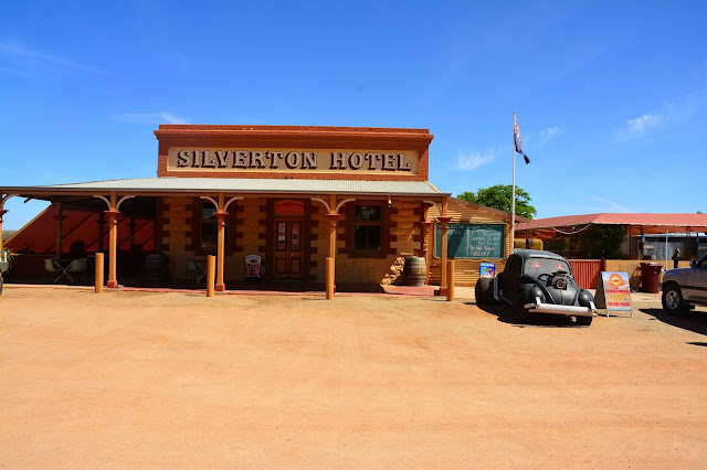
A short walk down the street, we came to the famous Silverton
Hotel, which has been in many, many films and TV commercials. Inside we walked and started reading the
history of the hotel, as well as looking at the many photographs. This is another great spot to stop and vist.
The owner of the hotel recommended going to the local gaol,
as it was well worth a visit and so it was.
The gaol is set up, depicting the history of Silverton, as well as local
artifacts. I found the gaol to be very good in showing how and why Silverton
was placed on the map.
We stayed two nights as Penrose
Park and visting Broken Hill. I found
the town very nice and would come back to explore again, if we get the chance.
The day had arrived and we were
going to do some big drives. We headed
East across the Barrier Highway, first stop was Willcania, then Cobar to fuel
up, then onto a free camp, between Nevertire and Warren. This camp was to be our last with the
families we had been on this adventure with, as they were heading to Goondawindi
and we were headed to Coffs Harbour for a few days. The camp was nothing special, but very nice
to share with our friends. After the set
up, it was beers, cheese and biscuits to be had, whilst the kids played dodge
ball. It was nice to chat about the best
things we had encounted on the trip as well as the things we would do again.
The following morning, we all
said our goodbyes, heading into Gilgandra and then up the Newell Highway, to
Tamworth, Armidale, Ebor and down into Coffs Harbour for two nights. This was a welcomed sight, as we had put in
some big days driving.


